Chapter 4

 Stornoway,
Glasgow and Belfast
April 26, 27, 28 2024
Introduction
We have two more stops in Scotland, then head to Northern Ireland. We will stop at Lewis Island, in the Hebrides, then call on Glasgow, the second largest city in Scotland, before heading to Northern Ireland and Belfast. The weather continued cool and breezy, but somehow we continued to avoid any significant precipitation.
You can check where we were by referring to the map below. While Stornoway is not quite as far north as Kirkwall, the Hebrides are still a bit out there with their share of wind and cool.
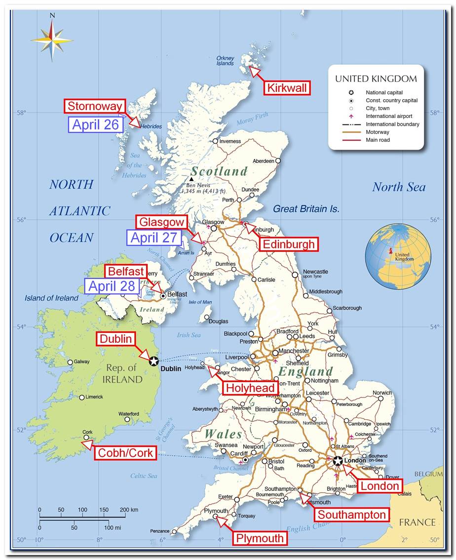
Around the top of Scotland and back down between Scotland and Northern Ireland
Stornoway, Scotland: Friday, April 26
The day started off with the standard routine: breakfast in the Terrace Café, get our stuff together, wait for time for our excursion, depart the ship, load onto the tour bus, and head off on our tour for today. Our excursion today is named simply “Historic Lewis”. (Lewis is the name of the island on which Stornoway is located.) The cruise dock and adjacent facilities look very new, even unfinished, and we found out later that Sirena was only the second cruise ship to visit this dock.
After a short 30-minute ride, our first stop was at the Carloway Broch. A “Broch” is a round stone structure, built over 2000 years ago, and used as both a living space for people and live stock and a fortified defensive tower. It was built on top of a ridgeline and definitely had a commanding view of the surrounding countryside.

Carloway Broch sits on top of a tall hill close to the sea.
From the Broch, you could look out over the ocean in one direction, and over the countryside in the other direction. I’m sure the location was a good one for the intended purpose of the Broch, but I could not help but think what a wonderful site that would be for a summer home. I say “summer home” because I’m not at all sure I’d want to be there during the winter storms I suspect frequent the area.

The view over the countryside, with sheep in the fields
Only a relatively small part of the broch was still intact., but you could visualize about how it would have looked 2000 years ago.

Only about a third of the broch remains standing.
The broch would have had three levels inside the walls. The entry is on the bottom-most level which was also where the livestock was kept when they needed to be inside. The second level was primarily for the kitchen and sleeping quarters with the top level being the general living/working area. The roof was probably wood beams and covered with thatch but there are not enough remains to be sure. Openings in the outside walls are kept to a minimum to keep out the weather and any attacking groups. Note the rather small/low doorway where the person in the red jacket is entering above.
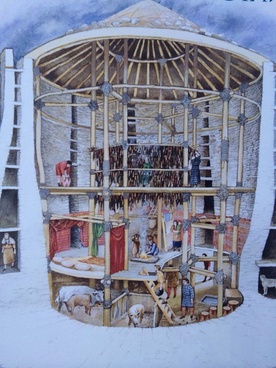
An artist drawing of what a broch might have looked like
The exterior walls were really double walls with significant space between them. These were probably used for storage and during the colder months they would function almost like a refrigerator.
After looking around for a while, we loaded back into the bus and headed to our next stop where we would see another old form of housing, but not nearly as old as the broch. Black houses are long, round-cornered structures intended to keep the inhabitants warm in foul weather. The term “black houses” needs a bit of explanation. For hundreds, perhaps thousands, of years, the primary heat and energy source in this area has been peat. The peat is cut from large fields of it, carefully dried, and then burned as a fuel, similar to coal. It is a rather dirty fuel and creates a sooty black smoke when it burns. When the smoke settles on the houses, it turns them black, thus they are “black houses”.

A pile of dried peat bricks between the black houses.
There were several peat fires in the village of 5 or 6 houses and the smell was not unpleasant, almost sweet, but I’m sure it would be tiring after a while and breathing the smoke could not be healthy. Early forms of black houses existed as far as 2000 years ago and they were in actual use as late as the 1970s. The village we visited was in use until 1974 and it has been restored and is now maintained as a historical site.

The roofs of the black houses were being re-thatched.
While we visited, several workers were busy rethatching the roofs of the black houses and it appeared to be quite a task. This village was located at a small bay that would have provided easy access for fishing and trade, but the rocky opening to the bay would make it easy to defend from attacking boats, if necessary. There were several demonstrations in the village, such as a mechanical, foot powered, weaving machine or a form of loom. Another demonstration was very much in keeping with Scottish habits: they were burning peat to provide heat for a whisky still. The Scots do like their Scotch Whisky and are very proud of it.

The black houses were adjacent to this small bay.
All over Scotland we had been noticing a low growing shrub that appeared to be covered with yellow-orange flowers: they seemed to be everywhere.
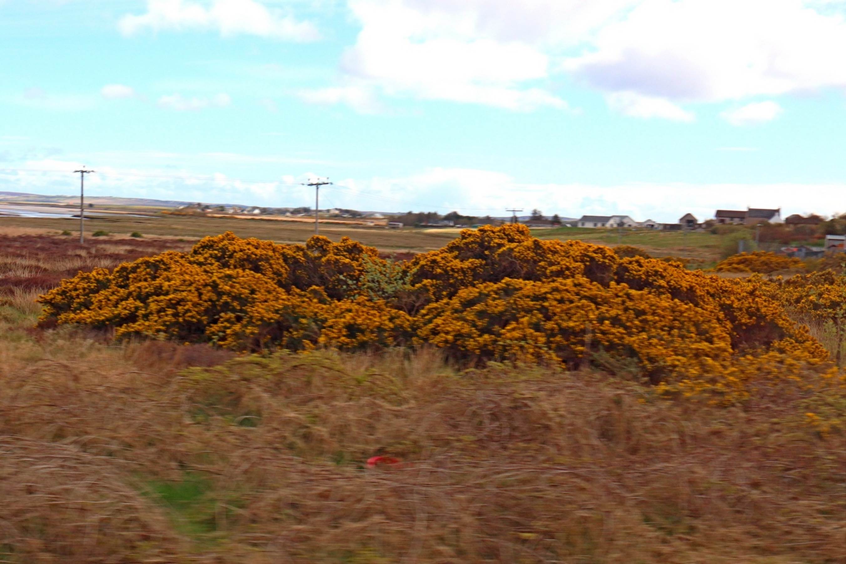
A patch of Grouse along the road
The shrub is called Grouse and was quite decorative this time of year. We also saw numerous fields throughout the British Isles covered with some crop that had a bright yellow flower. Some of the fields looked almost like a solid carpet of yellow. These turned out to be Rapeseed fields in full bloom. Rapeseed is closely related to Canola and they are both used to produce cooking oil, and the pressed and dried seeds can be used for cattle or sheep feed. The rest of the day followed the normal pattern: back to the ship for a slightly late lunch, relax and read until early evening. I did stop to take a photo of an interesting, if not especially colorful, sunset.

A slightly different sunset photo
Dinner was in the Grand Dining Room this evening and then we enjoyed some wine and cognac in the Horizon’s lounge. The entertainment was the same comedian as several nights ago so we skipped that.
Glasgow, Scotland: Saturday, April 27
Today would have another Scotland history lesson, but one that is a bit more recent than the previous couple of days. There are many stories about William Wallace and King Robert the Bruce during the late 1200s and early 1300s when there was a simmering revolt in Scotland against England. Some of the stories are certainly true, some mostly false, and some based on facts, but greatly embellished, and they all tend to meld together when studying this period in Scotland’s history. Today we would be looking into some of these personalities and stories and the locations where they played out.
Our primary destination was the Stirling Castle, which, appropriately, was located near the town of Stirling, where a major battle of the Scottish war of independence was fought. William Wallace is probably better known to Americans, due to the popular movie “Braveheart”, which somewhat covered his victory over the British at the Stirling Bridge. Robert the Bruce probably actually had a bigger hand in bringing about Scotland’s independence, but there is no modern popular movie about him.
As usual, we had a bus ride, about 45 minutes, through the beautiful countryside, to Stirling and the Stirling Castle. From the grounds at the front of the castle, you can see monuments to both William Wallace and Robert the Bruce.

Statue of Robert the Bruce with Wallace memorial in the distance.
The statue of King Robert the Bruce has a prominent site in front of the Stirling Castle but the Wallace memorial is certainly distinctive.
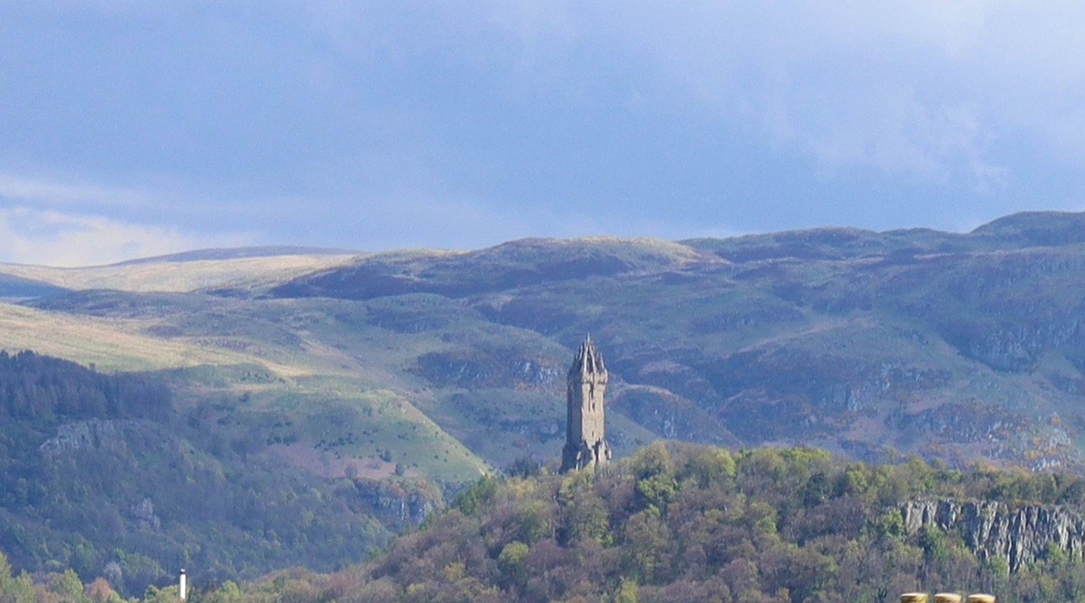
The William Wallace memorial
The photo immediately above is actually a cropped and enlarged section of the photo of the King Robert the Bruce statue. Although the two men never met in person while alive, they now have memorials within sight of each other.
Enough about these guys and history, let’s visit the impressive castle.

The entrance to Stirling Castle
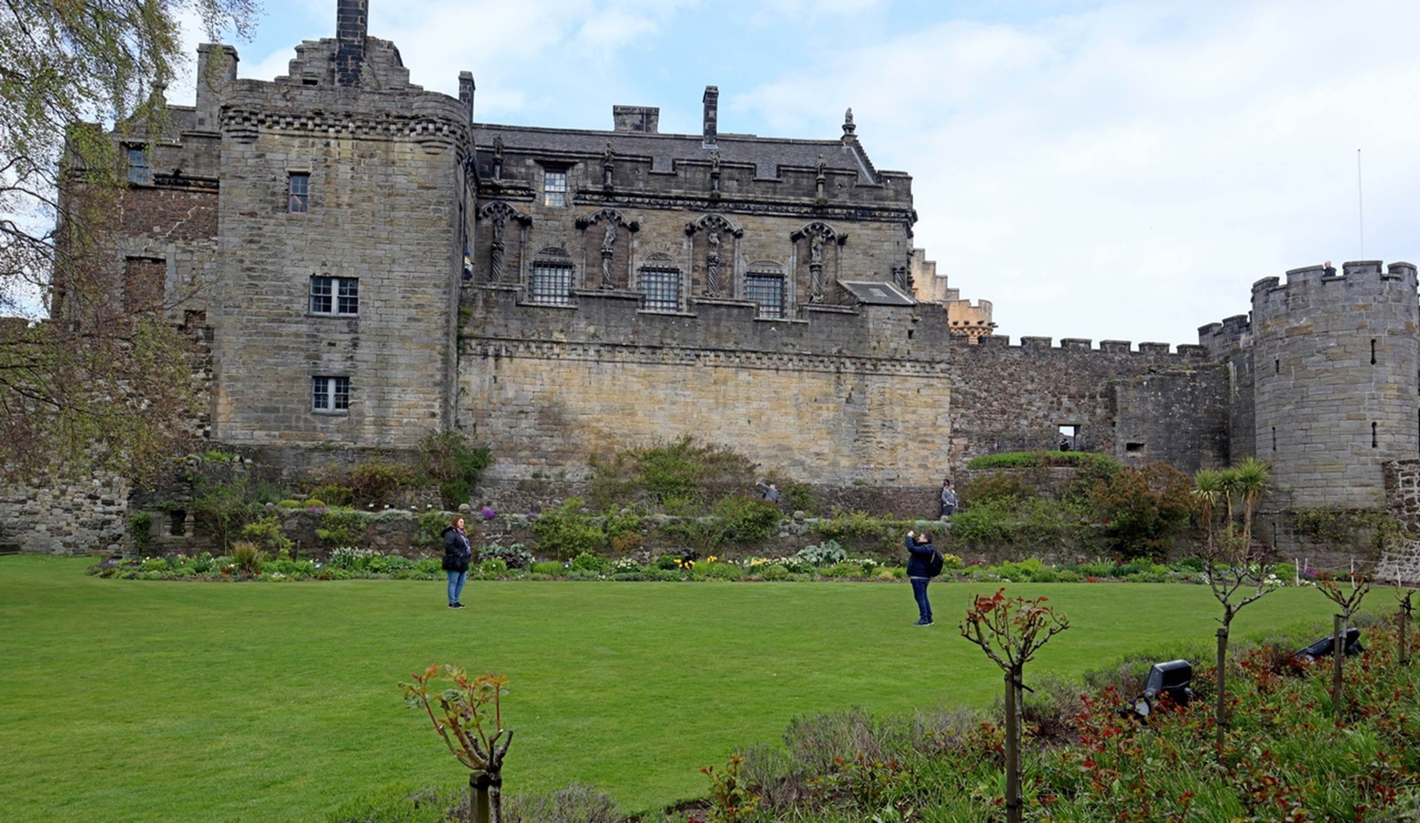
Our tour of the castle was “self-guided” so we referred frequently to the map of the grounds. We started by walking along the top of the walls for much of the perimeter of the castle, getting beautiful views of the surrounding area. The castle is at the top of a hill, providing a very good defensive position. Stirling is at the point where the flatter lands of the south turn into the highlands of the north so is strategically very important.

The central courtyard: chapel on the left and grand hall on the right
After circling the castle on the perimeter walls, we came back into the center of the castle and the central courtyard. Most of the important buildings were along the sides of this courtyard, like the chapel, the great hall, and the apartments for the royal residents.

The interior of the chapel
Once the castle was no longer necessary for the defense of Scotland, it was used for multiple other purposes, mainly as a military barracks and training facility. During this time the Great Hall was converted into a three level barracks and much of the timber roof structure was destroyed. After several hundred years of this usage, the military moved out in 1964 and soon a major renovation started which brought the castle back to about what it looked like in the 1500s timeframe.

The Great Hall: Note the complex wood timber roof structure.
The apartments or residences for the royal family were on the opposite side of the courtyard from the chapel. The king’s and queen’s outer and inner halls as well as their (separate) bedrooms were fully decorated as they would have been when occupied.

A docent was explaining details of the Queen’s inner hall.
The many tapestries were colorful and looked very heavy, and the ceilings were all brightly decorated. After touring the apartments, we wandered through the out-buildings and gardens for a while before deciding it was time for lunch.
Some of the gardens surrounding the Stirling castle
Speaking of lunch….. the excursion was scheduled for 10:30 – 3:30, which would get us back to the Sirena long after lunch food service was over, and there was no mention of food availability in the excursion description. Susan and I fell back on an old practice of making lunch sandwiches from breakfast foods. A couple of bagels smeared with mayo and mustard, a good helping of cheese and breakfast cold-cuts and we had very serviceable sandwiches. We enjoyed our lunch in the shadow of Robert the Bruce’s statue. After our enjoyable lunch, we loaded back into the bus and headed back toward the Sirena, docked at Greenock.
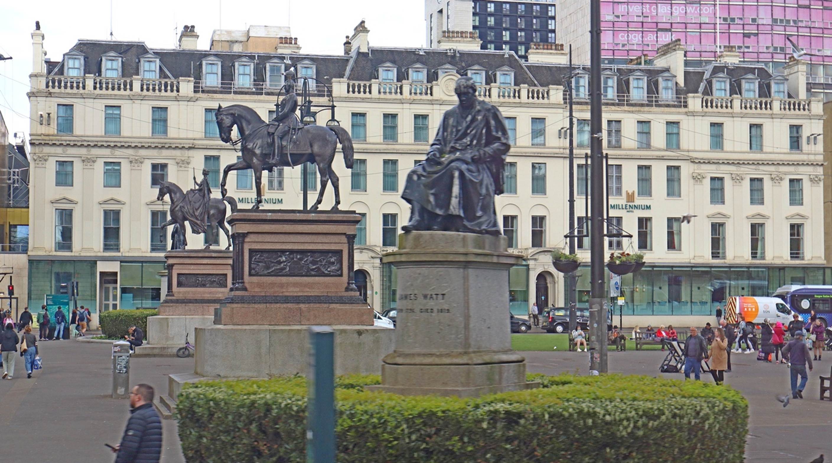
Three of the 12 statues in George Square
On the way back to the Sirena, we took a slight detour to come back through the heart of Glasgow. Probably the area of most interest was George Square in the middle of the city where there are 12 statues of important people in Scotland’s history. In the photo above, James Watt (inventor of a practical steam engine) is closest in a scholarly pose. Prince Albert (of the smoking tobacco in a can??) is next and the far statue is the only woman of the 12 statues, Queen Victoria, riding side-saddle.
As we got closer to Greenock, the port city for Glasgow, we passed Dumbarton castle on the opposite bank of the river Clyde from our highway. We also passed by a rather striking memorial to the many people who had been the shipbuilders at the port of Glasgow in the past.

The “Shipbuilders of Port Glasgow”
Tonight we paid our first visit to the “Tuscan Steak House” on Sirena. This was probably one of the better meals we had on the trip: Susan had the Dover Sole (nicely fileted at tableside) and I had the “small” prime rib. The prime rib deserves more explanation. It was offered in small (16 oz.) size and large (32 oz.) size. I selected the 16 oz size thinking it would be enough, and it certainly was. It had to be more than 16 oz.! Perhaps someone made a mistake and gave me a 32 oz. version, but it was big! There was no way I could reasonably finish it all, so I sliced the “leftover” into thin slices, put it on a plate that the server wrapped in plastic, and took it back to our cabin and refrigerator. The next day we would again make lunch sandwiches to go, using the prime rib.
The show this evening was the Sirena production party doing a show they called “Debonaire” that was supposed to be songs from the “Rat Pack” days of Frank Sinatra, Dean Martin, Sammy Davis Jr., Peter Lawford, etc. I only recognized one, possibly two, songs that the Rat Pack might have sung: I’m not sure where they got the others.
Belfast, Northern Ireland: Sunday, April 28
Belfast is known for past shipbuilding activities, such as building the Titanic, but there is still significant activity in the extensive harbor area where we were docked. We will see a little more of it later, but we started, as most days, by loading onto a bus for our excursion in Northern Ireland. Our primary target for the day is an interesting geological formation that is called the “Giant’s Causeway”. More about that name later…. First we had another nice ride along some beautiful country roads, looking at lots of sheep that had not been sheared yet this year. We sent from Belfast to the very northern coast of Northern Ireland where our first stop was to take a somewhat distant look at the ruins of the large Dunlace castle. I’m sure the castle was very impressive in it’s day, but the setting and the views around it were the best part. The story of the castle is that the lady of the house was not real happy with living so far from other people and did not like the castle. In a bad storm, some of the cliff supporting the castle was washed away, and a couple of rooms and some workers in them were washed away into the sea. The lady of the house now had a good excuse to move away. Based on the ruins of the castle, it is easy to imagine some of it falling into the sea: perhaps the story is true.

The ruins of Dunluce Castle
The Giant’s Causeway was only a short ride from Dunluce Castle. Once we got there, we left the bus to take a walk to the seashore and the rock formations.

The start of the path to the Giants Causeway.
There is a full visitor center on the cliff overlooking the causeway, but we skipped that and started down the path. There are shuttle busses that go down and back up the road to the causeway but most people walk the path going down. Quite a few people did opt for the $1.00 ride back up the hill on the bus.

The path and road to the Giant’s Causeway
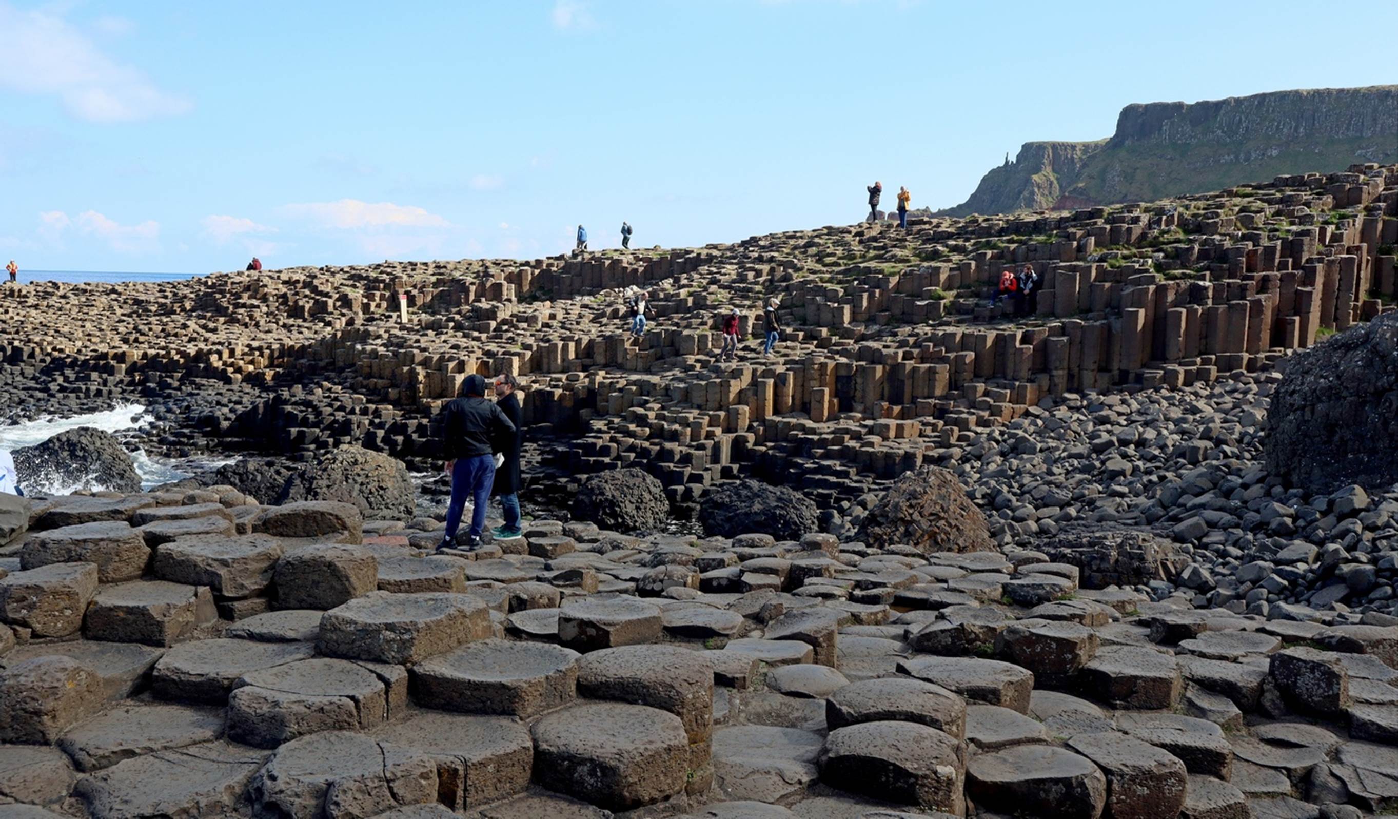
Before we even got to the causeway formation, the scenery and views were impressive with waves crashing over the rocky shore and the cliffs looking over it all. When we first saw the formation called the causeway, the reason for it’s fame was not obvious from the distance.

Look closely and you can see a couple of people out on the causeway.
We initially only saw a point of land sticking out into the sea with a few people climbing and walking over it. As we got closer, the unusual shape of the rocks was more evident. When volcanic actions caused the area to be inundated with lava and molten basalt, it cooled into these unusual forms. It is not unusual for lava to take unusual forms, but it is somewhat unusual to have such a large area take on such a consistent shape. About 60 million years ago, the lava flowed into this area, slowly cooled, and formed these five sided columns. The official estimate is that there are about 40,000 columns within the causeway area.

Want to try to count the columns?
The same cooling that formed the basalt into hexagonal columns also caused fractures at regular intervals within the column, causing the basis for blocks about 8 inches high.

There are both hexagonal columns and many individual blocks.
Over the millions of years since the columns were formed, the ocean waves have caused many of the columns to come apart, leaving thousands of surprisingly regular blocks scattered over the area. Today, there are still many columns, but also many individual blocks.
So, why is it called the “Giant’s Causeway”? There is a rather long story/myth in Irish folklore about the giants, but the short version is that the giants created the causeway so that they could walk over to Scotland (about 12 miles away, across the sea) and fight their rivals over there.
The formation covers a rather large area.
After getting a good look and climbing over and around the columns and stones for a while, we headed back up the path to the top of the cliffs. When we got back to our starting point we noticed there was a hiking trail that continued up quite a bit further. We had some time yet, so we followed it for a while, getting even better views of the area. If you want to get a better idea of just how the area looked, here is a composite video from five different viewpoints around the causeway.
At the appointed time, we all loaded back onto the bus for a short ride to our next scenic view, the Carrick-a-Rede rope bridge. We stopped at a parking area that provided a good view of the rope bridge, but we could not reasonably walk to the bridge from there. When I saw the rope bridge, I was actually somewhat glad that we would not be able to cross it ourselves. The rope bridge was originally built to allow salmon fishermen to get out onto the island from which the fishing was better. Today, it is only a tourist destination but I suspect it is much better maintained now than when it was only for the fishermen.

A distant view of the Carrick-a-Rede rope Bridge
Back into the bus and we continued our ride along the scenic coastline. After another 30 or 40 minutes, we stopped in the small coastal town of Ballycastle to stretch our legs and take advantage of the public restrooms. It had a picturesque little harbor with a few colorful boats moored there.
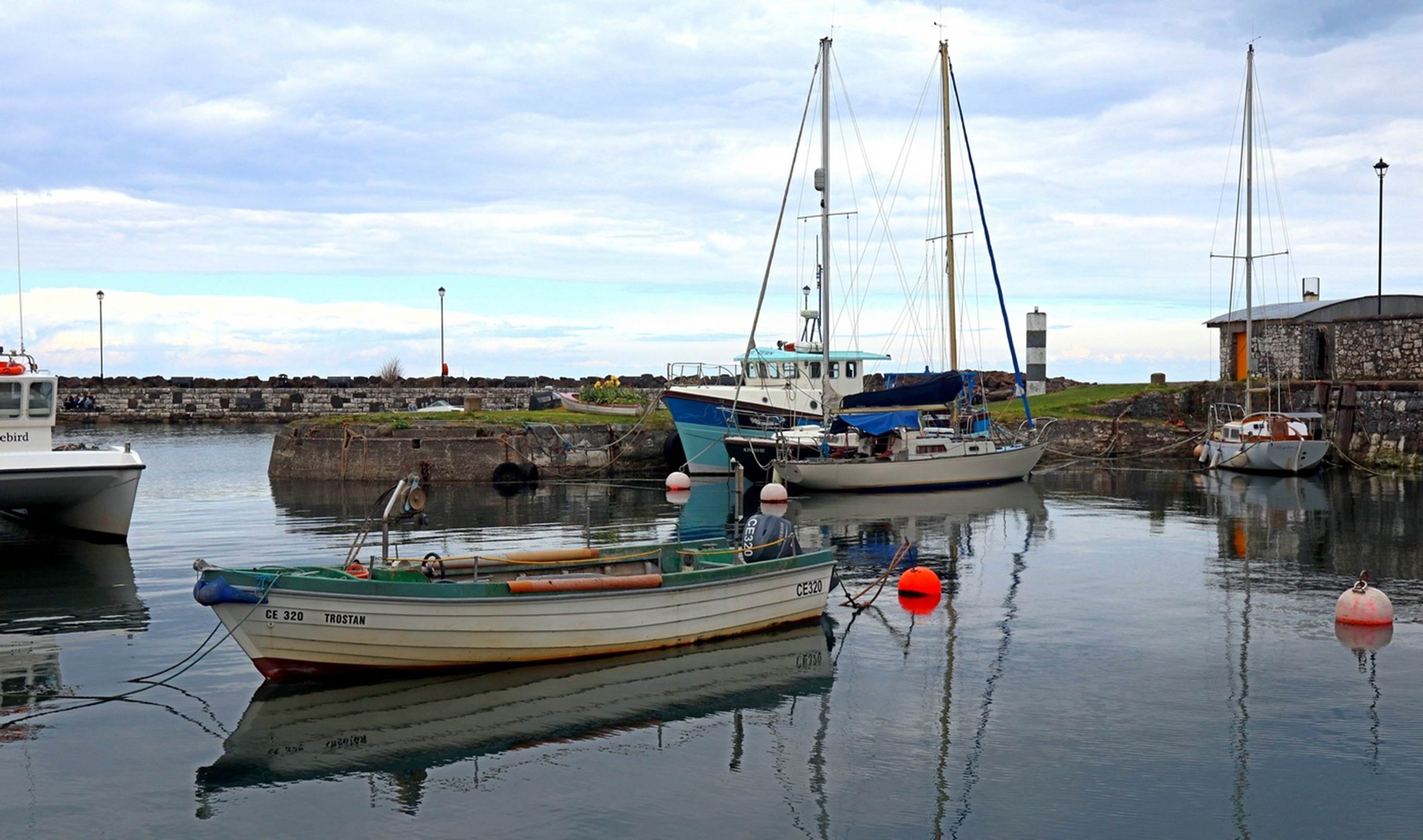
The harbor of Ballycastle
Another hour on the road brought us back to Belfast, but the tour was not complete yet. Our next destination was a drive-by viewing of some of the “Peace Walls”. The Peace Walls are essentially some rather ornate and high class graffiti that has been painted on what used to be the walls separating the religious areas of Belfast. Although there is still some segregation by religion in Northern Ireland, it is now mostly voluntary and not nearly as strict or onerous as it used to be. The paintings on the walls are mostly about social issues such as the segregation, poverty, politics and such. Painting on the official “walls” is controlled in a application/permit process to ensure reasonably equal access to the walls and that the paintings are not unreasonably offensive. In addition to the official walls, it appeared to me that many buildings, fences, and unoccupied buildings were used for many less carefully and thoughtfully done graffiti. You can see some of these colorful walls in this short video. The wall in the video is actually a very short one compared to the official “Peace Walls”.
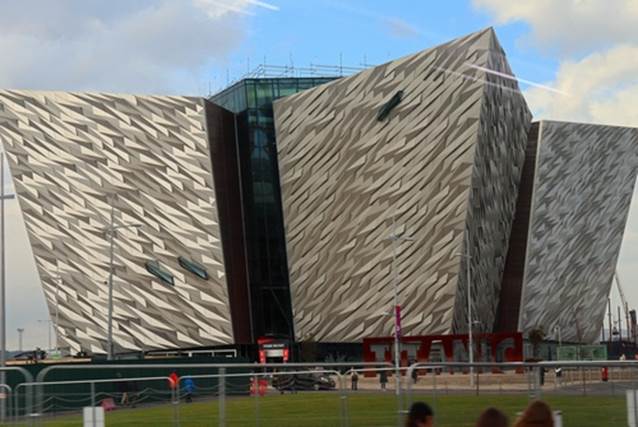
We left the Peace Walls and headed into the harbor area for one more sight before getting back to Sirena. The Titanic was built in the Belfast and the local tourist trade tends to make much of that fact. A new attraction in the harbor is the “Titanic Experience”. We did not have time to tour the facility, but all reports I saw suggested it is a very interesting and immersive experience. Our bus drove to the Titanic Experience building and more or less circled the building for us to take a good look. The shape of the building seemed rather strange until it was explained to us. The four sides of the building have triangular extensions jutting out from the central core. These extensions are supposed to be the same shape and size as the bow of the Titanic. I cannot verify that is accurate, but if so, the Titanic was definitely a large, dare I say “titanic”?, ship.

The extensions from the core of the building represent the bow of the Titanic.
We returned to the Sirena and relaxed for the rest of the day, enjoying some wine in the Martinis bar before dinner in the Grand Dining Room.

The Grand Dining Room with people in it.
By the time for dinner, I was getting a rather sore throat, so we asked to be seated by ourselves to avoid contaminating someone else. A couple of months previously, Susan had some illness characterized by a very sore throat and it turned out to be COVID-19. I was hoping that was not the cause of my sore throat.
The show for the evening was Nik Page again but this time he at least had more recognizable songs. After the show we stopped by for a visit to Martinis bar and, instead of my normal cognac, I treated my throat to a glass of Southern Comfort, which is known to do wonders for sore throats.
You can return to the mainline page by pressing your “Back-Button” or
You can just continue to Chapter 5